


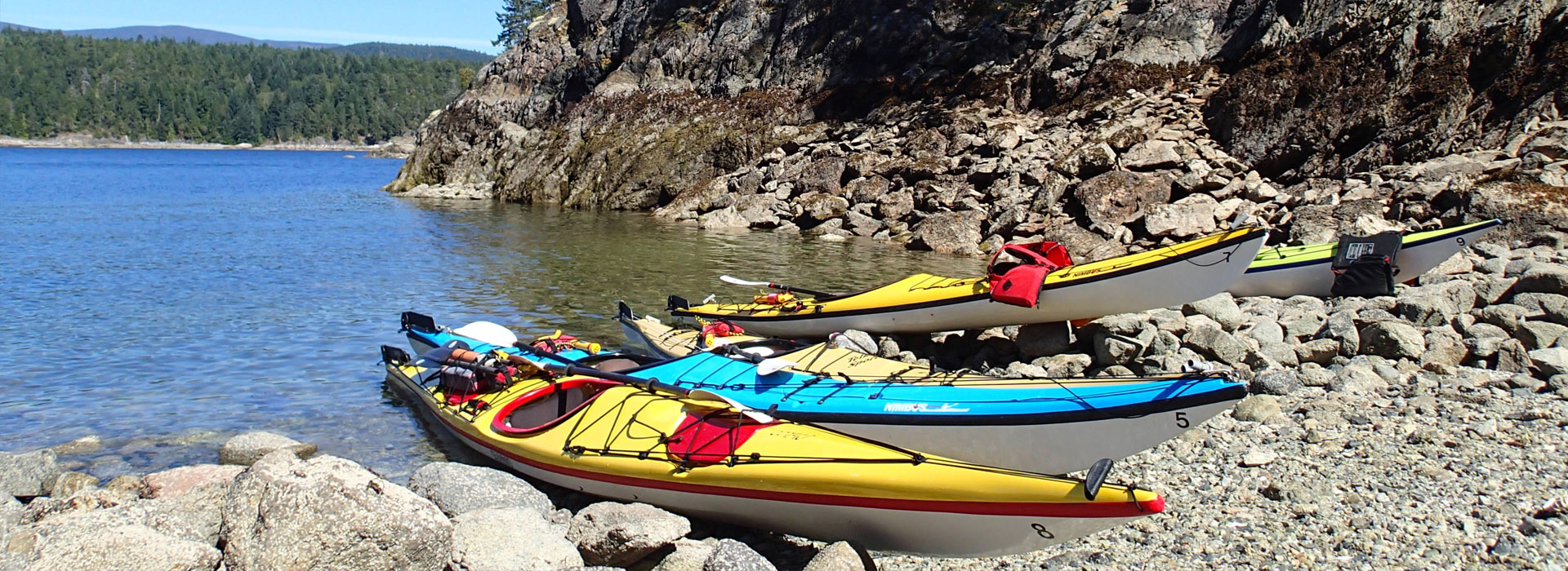
Coastal By Nature! A Guide to Local Paddling Destinations
The Powell River region includes some truly world class paddling destinations. Featuring warm and often sheltered waterways, paddling in this area is known to be suitable for paddlers of all abilities. Visit www.discoverpowellriver.com for complete area information for visitors. From short half or full day trips to weekends and longer multi day journeys the region has long been thought of as a Sea kayakers dream destination. With more than 20 years local outfitting experience here’s a guide to some of our favorites;
Copeland Island Provincial Marine Park
Comprised of five major islets a short distance North of Lund, the “Ragged Islands” as Locals refer to them make a perfect half or full day trip from Lund. Protected as a BC Provincial Marine Park, this archipelago of islands provides a perfect single day or overnight adventure. Crossing over Thulin Pass as you paddle north from Lund, the southern Copeland Island offers a large picnic site best accessed from the east side. Paddle close into the shoreline to appreciate the phenomenal intertidal marine life. Add to that a wide range of Sea birds and ducks as well as Seals, Sea Lions, and cetaceans such as porpoise and dolphin and other marine mammals. Keep your eyes open for evidence of the rich cultural and archaeological story of the area. Canoe runs, midden piles as well as pictographs found on these islands are a proud part of the story of the Tla’Amin Nation. The Middle and Northern Copeland Islands feature large group campsites. More information on the park, and these campsites as (as well as fees) can be found here... Copeland Islands
Hurtado Point and Dinner Rock Park
Located to the South of the Lund Harbor, this day trip from Lund sets you on a course beneath towering rocky cliffs and outcroppings, festooned with coastal flora such as Douglas Fir, Arbutus and Manzanita. Like a vertical zen garden, this stretch of coastline is free from residential development and is the route we suggest to paddle if you are heading to Savary Island. Named after an ancient story from the Tla’Amin Nation, Hurtado Point and its caves situated at waters edge were once the home of a malicious double headed sea serpent named Ayhoos. At this point you can cross over to Savary Island or continue south to Dinner Rock Forestry Campsite, where a rocky beach makes for a tricky landing, but camp sites and outhouse facilities make for a good camping or rest stop.
Desolation Sound Marine Park
Just a few hours from Vancouver BC, Desolation Sound is a world-renowned marine park destination. Featuring a spectacular backdrop of the rugged coast mountain range the park presents the multi day kayaker with many not to be missed options for an unforgettable journey. Picture deep clear waters that give way to a spectacular back drop formed by the Coast Mountain Range. At the centre of it all, the iconic Matterhorn-like peak of Mt Denman towers 1991 meters above the Sound. To the north Mt Adenbrooke rises dramatically 1600 meters above sea level one of the deepest places on the BC coast. As the Territory of the Tla’Amin Nation the area boasts a rich cultural history including early exploration by both the British and Spanish explorers who searched the area initially for the famed North West Passage. Filled with miles of inlets, islets, coves and bays and surrounded by rich temperate coastal rainforest the Desolation Sound is alive with an abundance of aquatic, intertidal and terrestrial life. It is not uncommon to enjoy tranquil moments with Bald Eagles, Harbor Seals, Sea Lions as well as Pacific White Sided Dolphins, Orcas and other cetaceans such as Humpback whales. With a wide range of available campsites, Desolation Sound is the ideal paddling destination for trips ranging in length from two days or more. For more info... Desolation Sound Marine Park
Don't have time to experience a multi day kayak trip in Desolation Sound, but still want to paddle there? Check out our kayak tours page for more information.
Savary Island
Boasting the warmest water north of Baja Mexico, (thanks to the warm southern tide) and ring of gleaming white sand beaches, Savary Island is a little piece of paradise sometimes referred to as the Hawaii of the Pacific Northwest. If you are seeking a real getaway in a sub-tropical setting Savary Island is a perfect destination for you. The island has no power and no public campsites or washrooms. Overnight visitors are welcomed however, at several cottage rentals, B&B’s and a private campsite. Day trippers can paddle over by Sea Kayak or can be dropped off or picked up at the public warf. The best way to get around is to cycle from beach to beach. Prime paddling stops include South Beach, Duck Bay, Sutherland Beach, and the Malaspina Promenade. Savary Island is home to a large range of highly sensitive ecosystems from sand cliffs to dune meadows and ancient forest dunes. Look for ancient glacial erratic’s on the South side of the Island on a low tide. For more information visit Check our Store to find Savary guide books and maps for Savary Island or go to... Savary Island
Sarah Point and Feather Cove
Located on the mainland at the northern most tip of the Malaspina Peninsula, Sarah Point is poised at the entrance to Desolation Sound. In addition to stunning vistas of the immensely beautiful Coast Mountain Range, Sarah Point is also the starting point for hikes along the Sunshine Coast Trail. Voted by Outdoor Magazine as one of the worlds 50 top hikes, paddlers can stop off here to hike a short section of the trail that provides stunning views of Desolation Sound and beyond. A little past Sarah Point will bring you to Feather Cove Campsite, with its more gradual beach and access to the Sunshine Coast Trail this is a preferred stop over on the mainland for paddlers doing the Lund to Okeover Inlet loop. For more info... Sarah Point.
The Lund to Okeover Inlet Loop
A very popular kayak trip that features the best the area has to offer in a short period of time, the Lund Okeover Inlet Loop offers the touring paddler with a short window of opportunity a great paddling option. Starting or finishing at either of the Small Craft Harbors of Lund or Okeover Inlet you will need 2-day 1-night is the best time span to properly enjoy this journey. If you leave from Lund, paddle north through the Copeland Islands, perhaps via Major Rock or the Townley Islands, all offer excellent lunch stop options among sea birds, seals and First Nations culture. Heading east around Sarah Point consider overnighting at Feather Cove or on the east side of the inlet at Hare Point, which looks straight into the heart of Desolation Sound itself. If you have more time, consider circumnavigating Kinghorn Island before you head South down Okeover Inlet. Arrange with Terracentric to have your rental gear returned from Okeover Inlet back to our base in Lund.
The Hulks
Packed with maritime history, ten giants quietly floating in their final resting-place, proud ships, now stripped and silent, nevermore to travel the seven seas. Doomed to lie at anchor, calming the pounding seas as the breakwater for our pulp mill. These are the incredible hulks. Arrange for Terracentric to transport your kayaks for you and launch from Gibsons Beach to enjoy this more urban paddling experience. End your day at Willingdon Beach in Powell River with a dining experience at one of Marine Avenues many restaurants and eateries.
Major Rock
Located just 1.5 nm North West of Lund, Major Rock is the pinnacle of a large sub aquatic mountain. Rising from the sandy ocean depths more than 300’ below the rocky islet is a popular destination for the naturalist paddler. Sea Lions, Harbor Seals and many species of nesting and migratory birds call this island home. While you are there, you may even spot some of the regions Major Rock (Sea) Stars!
Jedediah Marine Park
Jedediah Island, located between Lasqueti and Texada islands in the Salish Sea off central Vancouver Island, has long been a popular destination for recreational boaters and kayakers. It is the largest and most diverse of a chain of more than 30 islands and rocky islets located north and west of Lasqueti Island. The interior of Jedediah is comprised of forest ecosystems where you will see a variety of mature tree species, including Douglas fir and arbutus, intermingled with rocky outcrops. In several areas evidence of previous human settlements are evident. While the park boundary includes only the upland area, a rich marine environment encircles Jedediah Island, which offers five secluded bays for safe harbour.
Jedediah’s isolation and tranquility make it an excellent destination for kayaking and wilderness camping. What sets Jedediah apart is its size – it is one of the largest island parks in the province. Some of the best camping areas are near the shoreline around Long Bay. Small bays on the east side of the island provide campers with a little more privacy, especially during the summer at the height of kayaking-touring season, when the island can get quite busy. Launch from the West side of Texada Island. For more info go to Jedediah Island.
Discovery Islands
Excellent kayaking opportunities make Discovery Island Marine Provincial Park a popular destination for visitors and local residents. The area is accessible from Victoria, where paddlers can launch from Cattle Point, just north of the Oak Bay Marina.
Kayakers paddling between Oak Bay and Discovery Island will be delighted by the wildlife along this route, which features a sensitive seabird nesting area and ecological reserve. Sightings of seals, sea lions, otters and Bald eagles are common around the park. Paddlers should be aware that these waters can be treacherous, as strong currents and frequent winds create dangerous conditions, including rip tides. Crossings are best made at slack tide in calm weather.
Discovery Island is a popular kayaking and camping destination for school groups and kayak instruction groups, who have experienced guides on hand. The park features a large, open field, southwest of Pandora Hill, where campers can set up a tent. The only facilities provided are a pit toilet, information shelter and picnic tables. Campfires are not permitted on Discovery Island.
A hiking trail system runs from the lighthouse on Sea Bird Point to the western shore of the park, where hikers can hike up Pandora Hill for sweeping views of the Olympic Mountains and surrounding area. In the spring, a colourful array of wildflowers blooms in the woodlands and meadows.
Boaters should be aware that there is no safe anchorage and no moorage in the park - the closest safe harbour is in Oak Bay. Mariners should exercise extreme caution, as the main access to the park is via the rock and reef-strewn Rudlin Bay, which is exposed to the elements from the Strait of Juan de Fuca and Haro Strait.
The northern portion of Discovery Island, adjacent Chatham Island and some of the smaller islands nearby are First Nations Reserve lands. Please respect these areas. Several of the nearby islands constitute parts of the Oak Bay Island’s Ecological Reserve. These habitats are extremely sensitive to human disturbance and vulnerable to the introduction of non-native animal or plant species. Please do not enter into these areas.
For more info go to Discovery Islands.
Malaspina (Okeover) Inlet
Malaspina Inlet otherwise known as Okeover Inlet is an inlet on the east side of Desolation Sound in the South Coast region of British Columbia, Canada, located between Malaspina and Gifford Peninsulas. Sidewaters include Thors Cove and, Theodosia Inlet, The upper, southeastern, end of Malaspina Inlet near the City of Powell River is called Okeover Inlet on the east side of which the steamer landing Larsons Landing is located. Grace Harbour is located on north side of Malaspina Inlet on the southwest side of Gifford Peninsula. Paddling in Okeover provides the day tripper with a different feel than paddling from Lund. As the inlet narrows before emptying into Desolation Sound to the North, gentle tidal currents provide a steady conveyor of nutrients to abundant intertidal marine life. With warm waters and , an active mariculture industry abounds since and the area is a prized.
Homfray Channel
For the more ambitious paddler looking for a truly remote and rugged multi day paddling adventure, a circumnavigation around East Redonda Island is one of our favorites. Set aside as a Wildlife Refuge, East Redonda Island rises some 2.25 km from the ocean floor to its summit on Mt. Adenbrooke. Starting in Lund, paddlers who choose this option should be prepared for a six to seven day adventure depending on weather and other variables. While camping is available along the way, paddlers who choose this option should be well prepared for a more remote back country experience. Along the way this trip will take you through the Copeland Island Provincial Marine Park as well as Desolation Sound.
Toba Inlet
Located at the top of Homfray Channel, Toba Inlet is one of the lesser, but still principal, inlets of the British Columbia Coast. It is fourth in the series north from the 49th parallel which begins with Burrard Inlet, which is the harbour for the city of Vancouver. For the experienced multi day or expeditionary paddler Toba is a popular choice. Steep walled cliffs and mountains that seem to rise effortlessly straight from the emerald green glacial waters depths provide abundant water falls at various times of year. With far fewer suitable Kayak camping spots a trip into Toba Inlet requires several days and paddlers should be prepared for a Toba Wildernest.
Toba Inlet is relatively short in comparison to the other major coastal inlets, being only about 2.5 kilometres (1.6 mi) in average width and 35 km from the mouth of the powerful (but short) Toba River to the inlet's mouth at the junctions of Pryce Channel and Homfray Channel at the north tip of East Redonda Island.
What about the Weather?
Sea Kayaking on the coast of British Columbia often means kayaking in the rain. As the saying goes, there is no such thing as bad weather in BC, only bad rain gear! So get good gear before you come!
Our cancellation policy is still in effect during rainy days. Wind however is considered a much larger concern for paddlers and we will often alter plans with you if it is too windy to paddle. If this is the case, our staff will advise you as to what your options are at that time.
Local Area Trip Planning Help
Our trained staff are also avid adventurers and paddlers with an intimate understanding of the area. Call ahead or book some time with us before you depart so that you benefit form our local wisdom. Our staff paddles the area year-round. Please feel free to discuss your single or multi day trip itinerary.